 This Is Not A
BLOG!
This Is Not A
BLOG!
Date: 05/07/20
Rocko Paths Revisited
If you're waiting for Part 4 of my musing upon redundancy and what comes after it (following on from this, this and this), then it might turn up sometime soon; I'm still absorbing the consequences.
Nearly eleven years ago, I wrote this piece about how an area of the village which had been central to my childhood play had become disused and overgrown. I provided a rather scrappy map to illustrate where the old paths had been, just so that someone from the future would be able to see.
The thought occured to me only a couple of days ago that there was a better way of doing it available to me now, so I screen-shotted (screen-shat?) a portion of Google Maps' satellite image of the place and - somewhat artlessly, I admit - overlaid it with the paths. Rather then simply replace the image on the original post - where no-one would ever visit or notice - I thought I might as well give it its own page.
Here's the map:
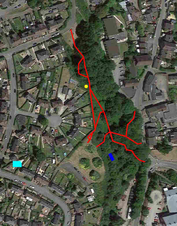
(As before, the paths are in red, the yellow circle is the Thrupenny Bit, the light-blue rectangle is the house I was born and brought up in, and the dark blue rectangle is John Arthur Davies' pigeon kit).
You might think that the paths are, on the whole, in clear areas without trees on them. But here's a photo I took a couple of summers ago which gives the lie to that impression and further illustrates my original point. It's looking south-east from the Thrupenny Bit, and shows that the places where we sat, ran or even gambolled are now nothing more than a sea of bracken:

And so does the world around us change.
File under: Me


